Use Leaflet in your django projects


Project description
django-leaflet allows you to use Leaflet in your Django projects.
It embeds Leaflet in version 0.7.2.


Main purposes of having a python package for the Leaflet Javascript library :
Install and enjoy ;
Do not embed Leaflet assets in every Django project ;
Enjoy geometry edition with Leaflet form widget ( Django >= 1.6 ) ;
Control apparence and settings of maps from Django settings (e.g. at deployment) ;
Reuse Leaflet map initialization code (e.g. local projections) ;
- note:
django-leaflet is compatible with django-geojson fields, which allow handling geographic data without spatial database.
INSTALL
Last stable version:
pip install django-leaflet
Last development version (master branch):
pip install -e git+https://github.com/makinacorpus/django-leaflet.git#egg=django-leaflet
USAGE
Add leaflet to your INSTALLED_APPS
Add the HTML header:
{% load leaflet_tags %}

<head>
    ...
    {% leaflet_js %}
    {% leaflet_css %}
</head>
Add the map in your page, providing a name:
...
<body>
    ...
    {% leaflet_map "yourmap" %}
    ...
</body>
Your map shows up!
Use Leaflet API
You can use the Leaflet API as usual. There are two ways to grab a reference on the just initialized map and options.
Using Javascript callback function
The easy way :
<script type="text/javascript">
    function map_init_basic (map, options) {
        ...
        L.marker([50.5, 30.5]).addTo(map);
        ...
    }
</script>

{% leaflet_map "yourmap" callback="window.map_init_basic" %}
Using events
If you don’t want to expose global callbacks :
<script type="text/javascript">
    window.addEventListener("map:init", function (e) {
        var detail = e.detail;
        ...
        L.marker([50.5, 30.5]).addTo(detail.map);
        ...
    }, false);
</script>
Event object has two properties : map and options (initialization).
For Internet Explorer support, we fallback on jQuery if available
$(window).on('map:init', function (e) {
    var detail = e.originalEvent ?
                 e.originalEvent.detail : e.detail;
    ...
    L.marker([50.5, 30.5]).addTo(detail.map);
    ...
});
If you want to support archaic browsers and still avoid jQuery, django-leaflet comes with a minimalist polyfill for events. Add it in <head> this way
<!--[if IE 8]><script src="{% static "leaflet/eventlister.ie8.js" %}"></script><!--<![endif]-->
<!--[if lt IE 8]><script src="{% static "leaflet/eventlister.ie6-7.js" %}"></script><!--<![endif]-->
Customize map size
CSS is your friend:
<style>

    .leaflet-container {  /* all maps */
        width:  600px;
        height: 400px;
    }

    #specialbigmap {
        height: 800px;
    }

</style>
Configuration
In order to configure django-leaflet, just add a new section in your settings:
LEAFLET_CONFIG = {
    # conf here
}
And add some of the following entries.
Spatial extent
You can configure a global spatial extent for your maps, that will automatically center your maps, restrict panning and add reset view and scale controls. (See advanced usage to tweak that.):
'SPATIAL_EXTENT': (5.0, 44.0, 7.5, 46)
Initial map center and zoom level
In addition to limiting your maps with SPATIAL_EXTENT, you can also specify initial map center and zoom level:
'DEFAULT_CENTER': (6.0, 45.0),
'DEFAULT_ZOOM': 16,
The tuple/list must contain (lat,lng) coords.
Default tiles layer
To globally add a tiles layer to your maps:
'TILES': 'http://{s}.tile.openstreetmap.org/{z}/{x}/{y}.png'
This setting can also be a list of tuples (name, url, attributions).
If it contains several layers, a layer switcher will then be added automatically.
'TILES': [('Satellite', 'http://server/a/...', '© Big eye'),
          ('Streets', 'http://server/b/...', '© Contributors')]
Attribution prefix
To globally add an attribution prefix on maps (most likely an empty string)
'ATTRIBUTION_PREFIX': 'Powered by django-leaflet'
Default is None, which leaves the value to Leaflet’s default.
Scale control
Scale control may be set to show ‘metric’ (m/km), or ‘imperial’ (mi/ft) scale lines, or ‘both’. Default is ‘metric’.
Enable metric and imperial scale control:
'SCALE': 'both'
Disable scale control:
'SCALE': None
Minimap control
Shows a small map in the corner which shows the same as the main map with a set zoom offset:
'MINIMAP': True
By default it shows the tiles of the first layer in the list.
Global initialization functions and window.maps
Since 0.7.0, the leaflet_map template tag no longer registers initialization functions in global scope, and no longer adds map objects into window.maps array by default. To restore these features, use:
'NO_GLOBALS' = False
Plugins
To ease the usage of plugins, django-leaflet allows specifying a set of plugins, that can later be referred to from the template tags by name:
'PLUGINS': {
    'name-of-plugin': {
        'css': ['relative/path/to/stylesheet.css', '/root/path/to/stylesheet.css'],
        'js': 'http://absolute-url.example.com/path/to/script.js',
        'auto-include': True,
    },
    . . .
}
Both ‘css’ and ‘js’ support identical features for specifying resource URLs:
can be either a plain string or a list of URLs
each string can be:
absolute URL - will be included as-is; example: http://absolute-url.example.com/path/to/script.js
a URL beginning from the root - will be included as-is; example: /root/path/to/stylesheet.css
a relative URL - settings.STATIC_URL will be prepended; example: relative/path/to/stylesheet.css will be included as /static/relative/path/to/stylesheet.css (depending on your setting for STATIC_URL)
Now, use leaflet_js and leaflet_css tags to load CSS and JS resources of configured Leaflet plugins.
By default only plugins with 'auto-include' as True will be included.
To include specific plugins in the page, specify plugin names, comma separated:
{% load leaflet_tags %}

<head>
    ...
    {% leaflet_js  plugins="bouncemarker,draw" %}
    {% leaflet_css plugins="bouncemarker,draw" %}
</head>
To include all plugins configured in LEAFLET_CONFIG['PLUGINS'], use:
{% leaflet_js plugins="ALL" %}
{% leaflet_css plugins="ALL" %}
Leaflet map forms widgets
With Django >= 1.6, a Leaflet widget is provided to edit geometry fields. In previous versions, it falls back to simple text areas.
It embeds Leaflet.draw in version 0.2.2.
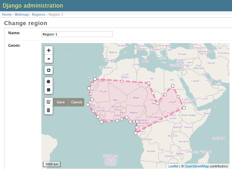
In Adminsite
from django.contrib import admin
from leaflet.admin import LeafletGeoAdmin

from .models import WeatherStation


admin.site.register(WeatherStation, LeafletGeoAdmin)
In forms
from django import forms

from leaflet.forms.widgets import LeafletWidget


class WeatherStationForm(forms.ModelForm):

    class Meta:
        model = WeatherStation
        fields = ('name', 'geom')
        widgets = {'geom': LeafletWidget()}
The related template would look like this:
{% load leaflet_tags %}
<html>
  <head>
   {% leaflet_js plugins="forms" %}
   {% leaflet_css plugins="forms" %}
  </head>
  <body>
    <h1>Edit {{ object }}</h1>
    <form action="POST">
        {{ form }}
        <input type="submit"/>
    </form>
  </body>
</html>
Plugins
It’s possible to add extras JS/CSS or auto-include forms plugins everywhere:
LEAFLET_CONFIG = {
    'PLUGINS': {
        'forms': {
            'auto-include': True
        }
    }
}
( It will be merged over default minimal set required for edition )
Details
It relies on global settings for map initialization.
It works with local map projections. But SRID is specified globally through LEAFLET_CONFIG['SRID'] as described below.
Javascript component for de/serializing fields value is pluggable.
Javascript component for Leaflet.draw behaviour initialization is pluggable.
Advanced usage
{% leaflet_map %} tag parameters
callback: javascript function name for initialization callback. (Default: None).
fitextent: control if map initial view shoud be set to extent setting. (Default: True). Setting fixextent to False will prevent view reset and scale controls to be added.
creatediv: control if the leaflet map tags creates a new div or not. (Default: True). Useful to put the javascript code in the header or footer instead of the body of the html document. If used, do not forget to create the div manually.
loadevent: One or more space-separated window events that trigger map initialization. (Default: load, i.e. all page resources loaded). If empty values is provided, then map initialization is immediate. And with a wrong value, the map is never initialized. :)
Projection
It is possible to setup the map spatial reference in LEAFLET_CONFIG:
'SRID': 2154 # See http://spatialreference.org
Additional parameter is required to compute scale levels : the tiles extent in local projection:
'TILES_EXTENT': [924861,6375196,985649,6448688],
For more information, have a look at this example.
Example of TileCache configuration compatible with Leaflet:
[scan-portrait]
type=WMSLayer
layers=scan100,scan25
url=http://server/wms?
extension=jpg
tms_type=google
srs=EPSG:2154
bbox=924861,6375196,985649,6448688

[cache]
type=GoogleDisk
expire=2592000
base=/tmp/tiles
By default, django-leaflet will try to load the spatial reference from your static files at “proj4js/{{ srid }}.js”. If it fails, it will eventually rely on spatialreference.org.
TUTORIALS
AUTHORS

LICENSE
Lesser GNU Public License
Leaflet Copyright - 2010-2011 CloudMade, Vladimir Agafonkin
CHANGELOG
0.12 (2014-03-22)
Add support of GeoJSON fields
0.11.1 (2014-02-12)
Do not complain about tile extent if SRID is 3857
0.11.0 (2014-02-07)
Add control of metric and imperial in SCALE option (thanks @smcoll)
Upgrade to Leaflet.draw 0.2.3
0.10.1 (2014-02-03)
Upgrade to Leaflet 0.7.2
0.10.0 (2014-01-22)
Python 3 support (thanks @itbabu)
Added JavaScript test using Mocha
0.9.0 (2013-12-11)
Upgrade to Leaflet 0.7.1
Fix unsaved warning being always triggered on Internet Explorer.
Added DE locale (thanks @rosscdh)
Fix installation with python 2.6 (thanks @ollb)
0.8.5 (2013-11-05)
Fix name collision.
0.8.4 (2013-11-05)
Fix regression in Django leaflet options serialization.
0.8.3 (2013-11-05)
Switch to lazy gettext in leaflet module init.
0.8.2 (2013-10-31)
Fix drawing of multi-polygon (fixes #37)
Fix attached data for events with jQuery fallback (fixes #38)
Fix Javascript syntax errors when using form prefixes (fixes #40)
0.8.1 (2013-09-30)
Fix Leaflet library inclusion with “plugins=ALL” outside Admin.
Do not include translations in every widgets outside Admin.
Fix syntax error if form widget translations contains quotes.
Fix dependency error if Leaflet is loaded after the form widget in the DOM.
Respect plugins declaration order using OrderedDicts
Prepend forms assets (instead of extend) if PLUGINS[‘forms’] already exists.
0.8.0 (2013-09-18)
Renamed Leaflet map fragment template
Leaflet map geometry widgets for adminsite and forms (requires Django 1.6)
Fix geometry type restriction in form fields (fixes #32)
Use jQuery for triggering events, only if CustomEvent constructor is not available (fixes #27, fixes #34)
0.7.4 (2013-08-28)
Fix projection download error if not available
Compute resolutions the same way TileCache does it, and provide example of TileCache configuration.
Raise ImproperlyConfigured if TILES_EXTENT is not portrait (since not supported)
0.7.3 (2013-08-23)
Do not use console() to warn about deprecated stuff if not available (<IE9)
Fix apparence of Reset view control for Leaflet 0.6
Add French and Italian locales
0.7.2 (2013-08-23)
Fix JS error when no callback value is provided.
0.7.1 (2013-08-21)
Fix map initialization with default tiles setting
Fix map fitBounds() to SPATIAL_EXTENT in settings
0.7.0 (2013-08-21)
Breaking changes
The leaflet_map template tag no longer registers initialization functions in global scope, and no longer adds map objects into window.maps array by default. Use LEAFLET_CONFIG['NO_GLOBALS'] = False to restore these features.
Initialization callback function no longer receives the map bounds in second argument, but the map options object.
Deprecated
JS default callback function ( <name>Init() ) for map initialization is deprecated. Use explicit callback parameter in template tag, or listen to window event map:init instead. (See Use Leaflet API section in README.)
TILES_URL entry in LEAFLET_CONFIG is deprecated. Use TILES instead.
Settings lookup is restricted to LEAFLET_CONFIG dict. Most notably, SRID, MAP_SRID and SPATIAL_EXTENT at global Django settings level are discouraged.
New features
Add ability to associate layers attributions from settings
Add auto-include key for entries in PLUGINS setting, in order to implicity load plugins with leaflet_css and leaflet_js tags.
Rewrote map initialization, into less flexible and obstruvise way.
Use plugin system for Leaflet.MiniMap.
Add loadevent parameter to leaflet_map tag.
Map initialization is now idempotent, does nothing if map is already initialized.
Add ATTRIBUTION_PREFIX setting to control prefix globally.
0.6.0 (2013-08-08)
Upgrade to Leaflet 0.6.4
0.6.0a (2013-07-05)
Upgrade to Leaflet 0.6.2
Upgrade Leaflet.Minimap (rev 3cd58f7)
Upgrade Proj4Leaflet (rev f4f5b6d)
0.5.1 (2013-04-08)
Add minimap support
Drop Leaflet version switching
Update Leaflet to 0.5.1
Update Leaflet.Minimap
Fix apparence of Reset view button
0.4.1 (2012-11-05)
Fix div creation test in template.
0.4.0 (2012-11-05)
Remove imperial scale.
Add create_div parameter
0.3.0 (2012-10-26)
Remove max resolution setting since it can be computed
Allow scale control even if view is not set
Upgrade Leaflet to 0.4.5
0.2.0 (2012-09-22)
Fix packaging of templates
Use template for <head> fragment
Do not rely on spatialreference.org by default
Default settings for SRID
Default settings for map extent
Default map height
Default tiles base layer
map variable is not global anymore
0.1.0 (2012-08-13)
Initial support for map projection
Show zoom scale by default
Spatial extent configuration
Initialization callback instead of global JS variable
Leaflet version switching
Global layers configuration
0.0.2 (2012-03-22)
Add IE conditional CSS
0.0.1 (2012-03-16)
Initial working version


